
India and Nepal shared a very friendly relationship from long ago. Both countries have a common culture which strengthened this relationship; both countries provide visa-free access to each other’s citizens. But as we all know nothing is permanent in geopolitics, everything is just a matter of time. From last few years, Indo-Nepal ties are weakening due to land dispute. Another major reason for this bitterness is the new Communist government of Nepal, which is pro-China. This already deteriorating relationship got worse when recently Nepal released a new map of their country in which Nepal showed Kalapani territory as its own. In this article, we will try to understand the dispute between the two.
| Table of contents Location of Kalapani The dispute Consequences of this escalation |
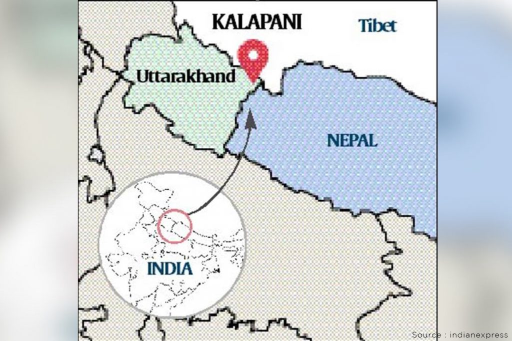
Location of Kalapani
The dispute over Kalapani territory between both countries is not new. But in order to understand this dispute, you must know the location of Kalapani. This region is located in the easternmost part of Pithoragarh district in Uttarakhand. Kalapani shares a border with the Tibet Autonomous Region of China on the north and with Nepal in the east and south. This region looks like a slice of cake wedged in between Limpiyadhura, Lipulekh and Kalapani. Currently, this region is in control of India but Nepal claims its right over the area because of historical and cartographic reasons. The area is the largest territorial dispute between Nepal and India consisting of at least 372-sq km area at the China-Nepal-India tri-junction.
The dispute
The Kalapani territory got its name from the river Kali. The claim of both countries to the region is on the basis of this river as it became the boundary demarcation of the kingdom of Nepal and British India after the Treaty of Sugauli signed between the rulers of Kathmandu and the East India Company ensuing Anglo-Nepal War. The treaty was signed in 1816. As per the treaty, Nepal lost control over the regions of Kumaon-Garhwal in the west and Sikkim in the east. Article 5 of the treaty says that the King of Nepal gave up his sovereignty over the region west of the river Kali which originates in the High Himalayas. Treaty further dictates that the British rulers will recognize the right of Nepal to the region beyond the east of the river Kali. The origin of the river Kali is the actual bone of contention. Nepal says that the east of the Kali river should begin at the source of the river. The origin according to Nepal is in the mountains near Limpiyadhura, which is higher in altitude than the rest of the river flow. Nepal claims that a landmass, high in the mountains that falls to the east of the entire stretch starting from Limpiyadhura downwards, is theirs. India, on the other hand, claims that the border begins at Kalapani which according to India is where the river begins. The dispute is mainly because of the different interpretation of the river’s origin. While Nepal’s claim of the territory east of Kali is based on the Limpiyadhura origin, India says the river actually takes the name Kali near Kalapani.
You may also like: SIKKIM
The dispute over the origin of the river, and the territoriality of Kalapani, was started by the Nepalese government in 1998. Nepal ignored the Kalapani issue until this year. Even when Indian military units held the Kalapani area to block Lipulekh during the Indo-China war of 1962, Nepal did not oppose. However, the relations were still cordial between both. The actual tension started in 2015 when there was a wave of anti-India sentiment in Nepal. Last year in October Nepal again claimed over this region. Recently, India built a road to reach Kailash-Manasarovar in Tibet, which passes through this region. Government of Nepal and even opposition parties of Nepal protested against the inauguration. In response to that Nepal released a new map, which includes the regions of Kalapani, Lipulekh and Limpiyadhura as part of its sovereign territory. Nepal has rejected India’s claim over these territories. Things get worse when Indian Army Chief M.M Naravane alleged that the Nepali government had opposed the inauguration of India’s link road to Mount Kailash in Lipulekh at the behest of China.
Consequences of this escalation
The further escalation of the dispute is not good for both nations. If we talk about Nepal, India is its largest trading partner also many Nepalese come to India every year for better job opportunities. So Nepal gets a good amount of remittance from India. If we talk about the geographic location, Nepal is a landlocked country and dependent on either India or China to get sea access. But the access to the sea for trade is more viable from India compared to China as the sea is much closer from India. India always helps Nepal in hard times just like recently India gifted HCQ medicine to Nepal. So, the escalation would not benefit Nepal anyhow.
On the other hand, this situation is not good for India also as India is fastly losing its neighbouring friends. This bitterness can push Nepal closer to China. This will strengthen the string of pearls theory of China and it will increase the dominance of China in South Asia. China is aggressively investing in Nepal, which is making Nepal pro-China. In such times India cannot afford this escalation.